Tuesday, May 30, 2023

Looking for Volunteers to Adopt a Trail Section

 Happy Spring / Early Summer everyone!   

Our local trail is looking for a few folks to volunteer to adopt a section of the trail.  All you need to commit to is a section, from X to X connector.  The work is simply weed-eating and pruning a section.  If interested, simply email me at shutesmtb@gmail.com

Currently I have gotten committals for 3 sections - A to B, L to M, and G to H

Start to A

A to B - by Scott A

B to D

D to E

E to F

F to G

G to H - by S. Capps

H to J

J to L

L to M - by Ryan S.

M to end of O

I'll update as the list fills up - Thanks in advance!!!

(Photo of Eris and my mistress)


Monday, May 18, 2015

8.1 Miles of Single Track and an Updated Map

The final section of trail from N to O has been completed.  The updated map is attached.  Kudos to Bill, Jeffrey, and Eric for laying this out and clearing it.  I think a few others helped some too.  We now officially have 8.1 miles of single track plus the connectors.


Saturday, June 28, 2014

It's been a while!!!

Trail is currently in great shape.  The kiosks have been updated.  Big thanks to all that have been maintaining the trail - Especially Jeffrey and his dad Bill!  In addition, check out the new Shutes Branch FB page created by Jeffrey.   Post up photos, rides, and other info.

We are hoping to do a fun event at the trail later this summer or fall - possibly a trail builders reunion.  Lets us know what you think at the FB page.  https://www.facebook.com/ShutesBranchMountainBikeTrail

And lastly, Shutes has an official Bike Trail sign and an address.  The address is now officially listed at Mount Juliet!

131 Shutes Branch Road
 Mt. Juliet, TN 37122


Sunday, May 12, 2013

The time has come for some trail trimming. If you are a regular rider, we need your help. Shutes Branch MTB Trail has been built and maintained by a handful of local riders for the past 5 years. The COE has provided us a great place to ride and enjoy the woods, but all building and maintenance is by volunteers only. This is Mt. Juliet / Old Hickory’s only mountain bike trail and the newest in Middle Tennessee. Help us keep it awesome by donating some time and effort.


We primarily need weedeating to trim the trails. The trimming needs to be 6 to 8 ft wide due to the height of many of the weeds that call Shutes home. Also, weedeaters work great on the newer growth that become face-slappers. Make sure to trim it to the ground and around all rocks. This will make the effort last longer. A light trimming will only last a few weeks.

If you don’t have a weedeater, pruners and loppers work great too for the face slappers. Just make sure to trim the branches so they don’t become little spears along the sides of the trail.

Please wear eye and hearing protection when weedeating or pruning. I use a forester’s helmet w/ screen face shield and safety glasses when trimming.

For those of you new to Shutes, the Jungle Weed will grow about 6 to 12 per week in the middle spring period. And, those pretty little white folwers become the world’s worst stick-tights that are great at ruining socks and gloves. But, if these plants are weedeated to the ground early enough, they pretty much give up. Most sections only need trimming once per year or less. Some sections will need trimming 2x per year, or more. Luckily, the COE will be spraying the beginner trail this month with herbicide. These sections would need to be mowed about 5 times.

Shoot me an e-mail at shutesmtb@gmail .com if you want to help volunteer!
AND - looks for the new connector signs.  BSA Troop 150 out of Mt Juliet just completed another Eagle project at Shutes.  The signs look great and will help folks find their way around the trails.

Thursday, December 13, 2012

Trail Map and Latest News

Shutes Branch trail building has generally ended.  Now what to do?  Improve some corners and improve lines - of course!!!  We'll be setting up some fun days of trail improvements soon, so we can make a great trail even better. 

Wet weather - please don't mud ride.  We don't have much soil to begin with, and mud riding makes it even less by promoting erosion.  If it's wet, take a hike.  Shutes is awesome for hiking.  It's so much different at a walking pace.  And bring your dog.  Just make sure to clean up after them if something gets worked loose by the hike :o)

Tuesday, November 6, 2012

Grand Opening Event a Success!!!

This past weekend, about 40 folks showed up for a grand opening sponsored by the US Army Corps of Engineers (COE) to celebrate the final trail building for the Shutes Branch MTB Trail.  This past spring, we finished cutting new trail - finally after 5 years of hard work. 

The Grand Opening started with some works from former Ranger Crystal Tingle (now Natural Resources Manager) and followed by some words from the person responsible for starting this project - Tommy Hatcher and from the person who finished it - myself - Steve Capps.   My right hand man - Eric Fisher was speechless after a late arrival from a vacation.

The trail started as an idea from some rangers to use the abandoned campground property for a mountain bike trail.  Tommy was contacted via Patrick Flowers (formerly w/ the Bike Pedaler).  The first part started as a mowed path through the open areas of the old campground - the beginners section was born.  After the fist section was cleared, organized trail building efforts were started via posts on the local forum - Nashville Mountain Bike - aka NMB (now called Tennessee Mountain Bike http://tennesseemountainbike.com/board/forum.php ).   The work was done by volunteers from the area as well as a few from farther away, including Clarksville, Murfreesboro, and Bowling Green, KY.  The local Middle Tennessee SORBA chapter also helped, especially by the use of their tool trailer.  Other tools - including the now famous Weed Wrenches - were loaned to us from the COE.  Over 2000 man-hours provided by more than 120 people over a 5 year period were needed to layout, cut, and most importantly - maintain the trail.  Without the support of the local biking community, this trail would not exist!  And we thank all that have helped out over the years.

The following is a link to a video produced by the COE's Amy Redmond (former Ranger) as well as a scan of the certificate of appreciation presented to the FOSB.   Another link shows some photos from the day's activities from the TN-MB forum.

http://youtu.be/MeIeZR4dQHE

http://tennesseemountainbike.com/board/showthread.php?15164-Shutes-Branch-Grand-Opening-(Nov-3)-plus-some-trail-work-in-Sept&p=127332#post127332

A special thanks goes out to Bikers Choice (Hendersonville and Mt Juliet), Swiftwick Socks, and Ride615 (Hermitage) for donating prizes that were given away during the cookout that followed this fun day of riding, socializing, and being recognized for the good that this loose-knit group of awesome people have done for our community - the Friends of Shutes Branch MTB Trail.

Sunday, September 9, 2012

We have 2 work days planned - the first one is on the Sept 22 and also on the following Saturday, the 29th. The 22nd is a general maintenance and corner improvement work day. The 27th is National Public Lands Day. The NPLD is sponsored by the COE and they will provide lunch. Both days will start at 8:30 and end around 12:00 to 12:30 The reason for 2 work days is that several of the regulars can't come out on the 27th, so we thought we would get a little done a head of schedule. I think that Skoby (Mike) will be the host for the 29th.


And the BIG EVENT - NO TRAIL WORK THIS DAY

Saturday November 3 - we'll be having our official GRAND OPENING w/ a ribbon cutting ceremony. We currently have a couple of shops lined up for some give-a-ways and hope to have a few more. We'll also have some fun stuff and group rides. We hope to have a bunch of folks that helped to come out and socialize and ride. The COE will have cake and drinks. And the Friends of Shutes Branch will have a cookout in the early afternoon. More details to come.

Steve

Sunday, July 22, 2012

Trail Updates: New Map and E-Mail Address

Here's the latest map - hope to get some posted up by the end of the week. 

And Shutes now has an E-Mail address: ShutesMTB@gmail.com

Please us this to let us know of any trees on the trail or any other info requests.

Steve

Sunday, April 8, 2012

Latest Map and the End of a Successful Season!

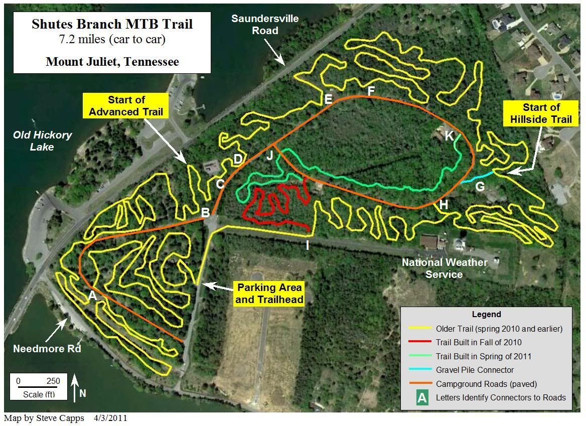
Here's a draft of the trail map. I'll put together a better one soon. The new stuff is in the campground inner circle and what we built this season is in red. This newest trail is about 1.1 miles long.  We have a little space to extend the trail a little more and exit a little farther down the road.   And, another of the old abandoned bathhouses got painted at yesterday's trail work day.   Should have been there - we had "real" burgers - YUM!!!  
Thanks to all the trail workers this year - with out you, this place would not be the awesome place to ride or walk in the woods that it has become.

Steve and Eric


Wednesday, February 29, 2012

We're Nearing Completion of the Trail

We're entering the 5th year of the Friends of Shutes Branch MTB Trail!   And we're finally about done.  We have two workdays scheduled - this Saturday March 3 and April 7 - also a Saturday.  There is a lot of new trail marked to clear and hope to have good weather and turnouts to finish.  The current trail is 7.8 miles long and will end around 8.5 miles!  Trail work begins at 8:30 - hope to see you there.  Also check Nashville Mountain Bike's Forum for more details.

We hope to have a big cookout at the April 7 work day to celebrate our accomplishment.

Tuesday, August 16, 2011

Trail Maps Now on Kiosks

We now have 2 Kiosks on the trail with Trail Maps and other info.  A recent Girl Scout project by Carrie C. included the construction of 2 kiosks.  These are located near mile 2.4 (the beginning of the advanced trails) and at the Gravel Pile Connector - start of the Hillside section, around mile 5.   The Girl Scouts also did some litter removal and painted over the graffiti at the first bathhouse (a redo of a previous paint job). 

A Boy Scout Eagle Project will soon be underway with more trail improvements.

A big thanks from the FOSB!!!!!!!!!!!

This is the latest map that is posted on the kiosks:

It's That Time Again - Public Lands Day - Sept 24 (Sat)

Every fall, the Corps of Engineers and the Friends of Shutes Branch hold a trail workday for Public Lands Day. This year we'll be finishing about 500 ft of trail that was rough cut this spring. If we get enough volunteers, we'll continue cutting new trail and hopefully will be exiting the woods at the bottom of the hill. Right now, it's 7.2 miles car to car, with about 1/2 mile on the campground road. Other work will include maintenance and tweaking the existing trails.

Schedule: Saturday September 24th --->>> Start at 8:30 am – End ??? Sometime in the afternoon???

Meeting Place: The parking lot at the trail-head (we’ll walk over to the end of the trail)

What to Bring/Wear: Long pants, work boots, gloves, and safety glasses. Don’t forget to bring a change of clothes for afterwards. Also, bring your favorite trail tool (make sure to put your name on it). We'll have some tools, including the world famous Weed Wrenches to pull privet and honeysuckle roots up. Also bring water and snacks to keep your energy level up.

Cookout: We’ll be cooking burgers and hot-dogs on the grill near the weather service radar tower. Food and drinks provided by the COE.

Play Time: After lunch, we’ll hit the trail and enjoy the fruits of our labor.

Wednesday, February 16, 2011

Latest Map and More Works Days


We're now over 7 miles of trail! Had a great ride tonight. The trail is in great shape. The new sections are already fun to ride. The latest map shows what we have built this fall/winter. The red was finished in 2010 and the green in 2011. Great job to all involved - I am very proud of this place. Good things happening there plus more in the future.


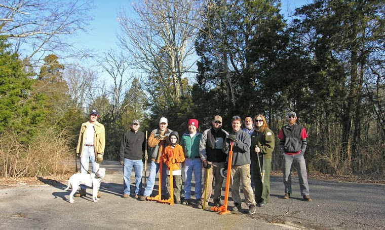
February 5th, 2011 Trail Crew

More Trail Work Days

We'll have a trail work day hosted by Eric Fisher on Saturday Feb 26th - 8:30 am. He'll have some tools, as usual. Make sure to bring gloves, safety glasses, and you favorite trail tool.

Eric will likely also lead one or two dates in March - with a couple of weekdays thrown in for those that work weekends. I'll get this posted as soon as I get info from him.

And we'll also have a "final" spring new trail clearing work day on April 23rd. We'll hopefully have great weather and a superdooper cookout at the trail. This might be the end for new trail other than reroutes and a couple of short extensions.

See ya on the trail!

Steve

Wednesday, February 2, 2011

Trail Work Saturday Feb 5th

It's that time again. This Saturday (Feb 5th) at 8 am, we're going to start clearing some more trail. We have about 1/2 mile to cut or complete. And if we get enough people, I'll send some out to do a little maintenance on the existing trail.

We'll meet around 8 am and try to start cutting trail by 8:30. There will be signs directing you to the parking spot, the last bathhouse if you do the loop clockwise.

I'll have the brush-cutter, weedeater, weed wrenches, pruners, pick-axes, and back-pack blower. If you have a good rake, pick-axe, favorite pair of pruners or other tools, bring them too. Make sure to label them with your name.

We'll end around 12:30 or so and might send someone out for pizza or head over to Shagor and eat some Indian food.

I'm looking for volunteers to lead some trail work days in Feb - April. Let me know if you can do this.

Monday, November 8, 2010

UPDATES and TRAILWORK SCHEDULE


UPDATES
Trail is in great shape - get out and ride before it gets muddy.

Check out NMB for the latest:
http://nationalmountainbike.com/board/showthread.php?p=99856#post99856

Latest maps update - I'd do a labeled map at the end of the season - but for now, here it is! The newest section is in red. 6.4 miles (plus about 0.3 back to the trail head on the road).


TRAILWORK
We're going to do some trail work soon to finish the last section that was opened up.

The first day is this Sunday (Nov. 14) after lunch (around 1 pm) - we'll meet at the parking spot to organize. This will be a little lower effort day since the Lock 4 6-hr race is the day before. I'm not getting the trailer, but will have weed wrenches, pruners, and pick-axes. Bring your favorite tool, some gloves, and SAFETY GLASSES - these are very important! If we have enough folks, we'll split into 2 or 3 small groups. I'd like to concentrate on finishing the last trail work. BTW - watching the Titans loose is not an excuse to not love your favorite trail - LOL - but if you must, DVR or tape it (Like Eric Fisher said he would do).
The next day planned is December 11 - it's a Saturday - and we'll meet around 8:30 at the bath house near the end of the trail (same place as the last work day). I should have the SORBA trailer for this day (if it's available). And if the forecast is good - we'll work out a cookout - I'll provide burgers and dogs - you provide the rest. I'd really like to know who can come out so we can plan the everything else part. If the weather is bad, we'll send out for some pizza like last winter. This day will be dedicated to more new trail cutting. Tommy should have the last of the perimeter section flagged.

I'll have a few more dates to post up in the near future.

Steve

Wednesday, September 29, 2010

Public Lands Day Success!

The work day went just as planned. We had a good turnout of 20 people, many first-timers. Firstly, the breakfast provided by chef Tim with the Bicyclette http://www.bicyclettecafe.com/ was awesome. Sausage biscuits and fruit w/ juice and coffee. The gravel piles section (Tommy's Folly) was completed, the trail extension was cut and partially finished, and some maintenance completed. Afterwards, we had burgers and a tour of the NWS office. Pretty cool place to visit. If your out riding the trail at 6 pm, you can see a weather balloon launch. It's done from the white building at the top of the hill.

The trail extension is about 1/2 mile long with a little bit left to flag and cut. The rideable part is 1/4 of a mile long. The remainder has been cut and cleared, but needs to be de-stobbed, weedeated, and blown. Part of this will be a challenge because of the size of the rocks. Some places will likely need 3 optional routes!

Monday, September 20, 2010

Parking and Work Area Map


I talked with the Swankmotee to day and decided to make a parking / work area map. If you have a nice vehicle, you might want to park at the entrance (labeled Parking Area #1) to the park and walk, due to possible branches hanging into the old campground roads. This is the general area to park when riding the trail.

The back side bathhouse is very near the trail extension and is where I'll have the SORBA Trailer and breakfast - plus registration and orientation for the morning trail work (labeled Parking Area #2). This will be our central "command post" and is close to the picnic area.

Two rules on parking -don't block the road and don't park on the NWS road.


We'll have some signs posted that morning to help folks find us. We'll probably draw the gift certificates just before lunch.

Steve

Meeting time is 8 am

We'll be meeting at 8 am and eat, socalize, fill out COE and SORBA paperwork, and prepare for the trail work.

Friday, September 17, 2010

September 25th Public Lands Day

It's time to start building some more new trail! Hoping for a big turnout so we can finish the perimeter section. We have the tool trailer lined up, some door prizes, lunch provided by the COE (grilling burgers and dogs at our secret spot under the weather ball), a tour of the National Weather Service office after lunch, and bike rides after resting up.

The work day will start around 8 - 8:30 Saturday morning. Don't forget your safety glasses and gloves.

Here's a link to a PDF of my flier (thanks Darryl!)

http://sorbamidtn.org/wordpress/wp-content/uploads/2010/03/Shutes-Sept-2010-Trail-Work-Day.pdf

We'll be doing a little more trail buffing next week before the work day. If you can do some trimming, the middle section of the beginner trail could use a little work.

See you next weekend!

Steve

Monday, July 12, 2010

Hello

Hello - still here. Trail is a blast - check it out - Homer (Gary) loves it. I personally recommend a there and back ride - 12 miles total - about 1 hour and 30 minutes or so. Great workout! Thanks to all that are helping to keep the trails in shape.

This September 25 (Sat.), we're going to have a fun day will some trail work beforehand. It's Public Lands Day and the COE is going to sponsor a lunch for us. Afterwards, the National Weather Service is going to give us a tour of the weather station. And this will be followed by fun rides - we might even race each other (LOL). More details to come!

Steve

PS - I set the comments section to be for followers only - hopefully no more spam