Subscribe to:
Post Comments (Atom)
The latest news on our neighborhood MTB trail located in Mt. Juliet, Tennessee.
Trail Location and Description
The MTB trail is located at Shutes Branch Rec Area on Old Hickory Lake, which is controlled by the Army Corps of Engineers. The rec area is located in north Mt. Juliet at the intersection of Saundersville Road and Needmore Road. From this intersection, travel a few hunderd feet on Needmore Rd. and take a left into the old campground. There is a sign for the National Weather Service at this entrance. The OHX doppler radar site is located on to of the hill A.K.A. "the weather ball".
Take the entrance road to the top of the hill and a parking area is located on the left side, near an abandoned bathhouse. The trail starts on the sidewalk and is currently 7.2 miles long, including a 1/2 mile road section. The first 2.4 miles of the trail are easy and smooth - great for beginners and a good warm-up. The next 5.5 miles are more advanced - lots of rocks, short ledges, and tight turns to hone your skills. When you get to the end turn around and you'll get almost 16 miles of riding in.
Take the entrance road to the top of the hill and a parking area is located on the left side, near an abandoned bathhouse. The trail starts on the sidewalk and is currently 7.2 miles long, including a 1/2 mile road section. The first 2.4 miles of the trail are easy and smooth - great for beginners and a good warm-up. The next 5.5 miles are more advanced - lots of rocks, short ledges, and tight turns to hone your skills. When you get to the end turn around and you'll get almost 16 miles of riding in.
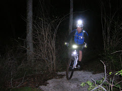
Night Riders


No comments:
Post a Comment